In a groundbreaking development, the European Space Agency (ESA) and the Japan Aerospace Exploration Agency (JAXA) have released a stunning image of the internal structure of a storm cloud, captured by their Earthcare satellite. This revolutionary image, obtained using advanced Doppler radar technology, promises to transform our understanding of cloud dynamics and their profound impact on global climate and weather forecasting.
The Mission: Earthcare Satellite
Launched in May, the Earthcare mission represents a collaboration between two of the world’s leading space agencies. This €850 million endeavor seeks to investigate the complex nature of clouds and aerosols, which play crucial roles in Earth’s climate system. By examining how these elements interact with radiation, Earthcare aims to improve our understanding of their influence on both climate change and weather patterns.
Objectives and Goals
The primary goal of the Earthcare satellite is to enhance our understanding of cloud-aerosol-radiation interactions. These interactions are vital for accurate climate modeling and prediction. By observing and analyzing these phenomena, scientists hope to refine climate models and contribute to more accurate weather forecasting.
- Cloud Dynamics: Understanding how clouds form, evolve, and dissipate is essential for climate science. Earthcare’s observations provide new insights into the processes that govern cloud behavior.
- Aerosol Impacts: Aerosols, tiny particles suspended in the atmosphere, have significant effects on cloud formation and behavior. By studying these interactions, Earthcare helps scientists understand their role in climate regulation.
- Radiation Balance: The Earth’s energy balance is influenced by the reflection and absorption of solar radiation. Earthcare’s data aids in quantifying these processes, contributing to a deeper understanding of global warming and cooling mechanisms.
Capturing the Interior Structure of Storm Clouds
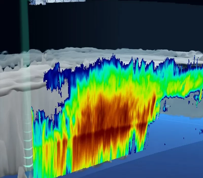
On 13 June, the Earthcare satellite captured a remarkable image over the Pacific Ocean, just east of Japan. This image offers unprecedented insights into the density of ice, snow, and rain within the storm cloud. More importantly, it reveals the velocities at which these particles descend towards Earth, crucial for understanding precipitation patterns and their implications for weather forecasting.
The Importance of Understanding Storm Clouds
Storm clouds are complex systems that play a critical role in Earth’s weather and climate. Understanding their internal structure helps meteorologists predict severe weather events and aids climate scientists in modeling future climate scenarios. The data collected by Earthcare allows for a more detailed analysis of these clouds, providing essential information about their composition and behavior.
- Density and Composition: By examining the density of ice, snow, and rain within clouds, scientists can better understand the processes that lead to precipitation. This information is crucial for accurate weather forecasting and climate modeling.
- Precipitation Patterns: Understanding the fall speeds of various particles within clouds helps meteorologists predict the intensity and duration of precipitation events. This data is vital for preparing for extreme weather conditions.
The Technological Marvel of Doppler Radar
At the heart of this breakthrough is the satellite’s Doppler radar, a technological marvel that measures the Doppler shift in radar echoes. This shift enables scientists to infer the precise fall speeds of particles within the cloud. What makes this achievement remarkable is the satellite’s ability to measure these speeds—some as slow as one meter per second—while hurtling through space at an astonishing speed of 7 kilometers per second.
How Doppler Radar Works
Doppler radar technology measures the frequency shift of radar signals as they bounce off moving particles. This shift, known as the Doppler effect, allows scientists to determine the velocity of particles such as raindrops, snowflakes, and ice crystals within clouds.
- Measuring Particle Velocities: By analyzing the Doppler shift, Earthcare’s radar can accurately measure the fall speeds of different particles within the storm cloud. This information is critical for understanding precipitation processes.
- Advancements in Radar Technology: The use of Doppler radar from space is a significant advancement in meteorological science. Previously, similar measurements were only possible from ground-based stations or research aircraft, limiting the scope of observation.
Insights from Mission Scientists
Dr. Robin Hogan, a mission scientist from the European Centre for Medium-Range Weather Forecasts (ECMWF), expressed his excitement over the radar images from Earthcare. He highlighted the unprecedented capability of measuring particle fall speeds globally, which was previously limited to a few ground-based radar stations and research planes.
The Significance of Global Measurements
The ability to measure particle velocities from space provides a comprehensive view of atmospheric processes on a global scale. This capability is essential for improving weather forecasting models and understanding the dynamics of Earth’s atmosphere.
- Global Data Collection: Unlike ground-based radar stations, which are limited to specific locations, Earthcare provides a global perspective on cloud dynamics. This comprehensive data collection enhances our understanding of weather and climate patterns worldwide.
- Implications for Weather Forecasting: By incorporating Earthcare’s data into weather models, meteorologists can improve the accuracy of forecasts. This improvement is crucial for predicting extreme weather events and preparing for their impacts.
Impact on Climate Science and Weather Forecasts
The implications of Earthcare’s observations extend far beyond scientific curiosity. By enhancing our understanding of cloud dynamics, the mission aims to refine climate models and improve the accuracy of weather forecasts worldwide. This could potentially revolutionize how we prepare for and mitigate the impacts of severe weather events.
Advancements in Climate Modeling
Accurate climate modeling is essential for predicting future climate scenarios and understanding the potential impacts of climate change. Earthcare’s data provides critical inputs for these models, enhancing their accuracy and reliability.
- Refining Climate Models: By providing detailed data on cloud-aerosol interactions and radiation balance, Earthcare helps scientists refine climate models. This refinement is crucial for understanding the potential impacts of climate change and developing effective mitigation strategies.
- Understanding Climate Feedbacks: Clouds play a significant role in climate feedback mechanisms. Earthcare’s observations help scientists understand these feedbacks, which are essential for predicting future climate conditions.
Improving Weather Forecasting
Accurate weather forecasting is vital for preparing for extreme weather events and minimizing their impacts on communities and infrastructure. Earthcare’s data contributes to the improvement of weather models, leading to more reliable forecasts.
- Predicting Extreme Weather: By providing detailed information on storm cloud dynamics, Earthcare helps meteorologists predict the intensity and duration of extreme weather events. This information is crucial for disaster preparedness and response.
- Enhancing Forecast Accuracy: Incorporating Earthcare’s data into weather models leads to more accurate forecasts, helping communities prepare for and respond to severe weather conditions.
Future Prospects and Expectations
As Earthcare continues its mission, scientists anticipate further revelations about cloud behavior across different regions and seasons. These insights will contribute to a more comprehensive understanding of Earth’s climate system, aiding policymakers, meteorologists, and researchers in addressing climate change and its multifaceted challenges.
Conclusion
The release of the interior structure of a storm cloud by the Earthcare satellite marks a pivotal moment in atmospheric science. By harnessing cutting-edge technology, this mission not only expands our knowledge of cloud dynamics but also holds the promise of transforming how we predict and respond to weather patterns globally. As we await more discoveries from Earthcare, one thing is clear: the future of climate science is looking brighter with each radar image captured from space.
In summary, the Earthcare satellite’s recent findings are not just a scientific breakthrough—they represent a leap towards a more resilient and informed approach to understanding and adapting to our ever-changing climate.